
Bathymetry is the measurement and mapping of the topography of a seabed or lakebed and one of the most practical use cases for WaterDrones. Instead of sending a crewed vessel into shallow and often difficult to access waters, an unmanned surface system can follow a predefined survey route and collect depth data efficiently.
Field test
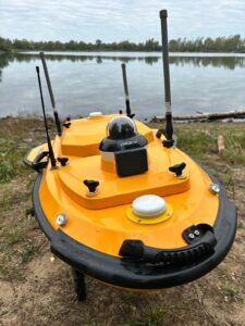
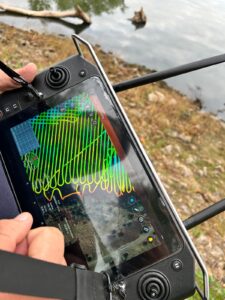
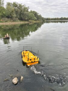
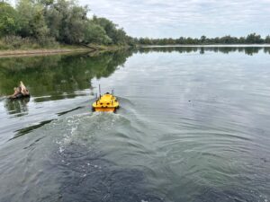
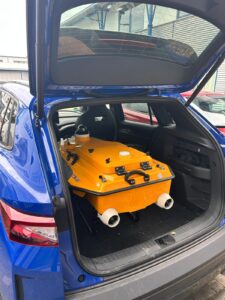
Over the weekend, I had the opportunity to attend a field test of the Apache 4, a WaterDrone system developed by CHNC. The test focused on measuring the depth of a lake using a singlebeam echosounder. The system was programmed with a set of predefined waypoints and a Geofence. The Apache 4 then followed this route across the lake while the single-beam echosounder measured the water depth below the vessel and associated each measurement with a geographic coordinate. This approach is particularly suitable for structured surveys in which the operator wants to cover defined transects or a regular grid. The resulting data can provide a basis for understanding the underwater profile of a lake, checking changes in depth or supporting maintenance, environmental and infrastructure-related work.
A singlebeam echosounder does not produce a continuous swath of the seabed in the same way as a multibeam system. Instead, it measures depth directly beneath the vessel along the planned track. The quality and usefulness of the survey therefore depend strongly on the route design, waypoint spacing, positioning accuracy and the purpose of the survey.
Stable operation on the water
A typical setup for autonomous cleaning in a marina or canal can take different shapes: The system appeared very stable in the water. The platform maintained its course and moved steadily along the predefined route, creating confidence that the sensor could collect consistent measurements under the conditions observed during the test. For bathymetric surveys, this stability matters. Unnecessary yawing, rolling or changes in speed can make data collection more difficult and may affect the consistency of the survey. A stable platform also makes the system easier to operate and reduces the amount of manual intervention required from the shore.
Radio communication and an accessible user interface
A key advantage of autonomous platforms is that they can combine tasks with additional sensors. For example, Communication between the operator and the system was established via radio frequencies though it is also possible to connect via mobile networks if a Sim card is being used. This allowed the Apache 4 to be controlled and monitored from shore without relying on a conventional onboard crew. The software was easy to handle and user-friendly. The interface reminded me strongly of the DJI ecosystem. The basic workflow was intuitive, the route planning was accessible and the system did not appear unnecessarily complicated for a first time observer.
Compared with DJI’s more mature ecosystem, however, the data processing and functionality appeared less sophisticated. This is not necessarily a disadvantage for every application. For many survey tasks, a clear and reliable workflow may be more important than a large number of advanced features.
A practical lesson: vegetation can affect the propulsion system
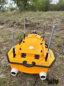
The test also highlighted a very practical operational issue: algae and other aquatic growth can interfere with the drive system.
This is easy to underestimate when focusing primarily on sensors, software and autonomous navigation. In real world inland water operations, however, vegetation, floating debris and sediment can affect propulsion, maneuverability and mission reliability. Regular inspection and cleaning of the drive system may therefore be essential, particularly during periods of heavy algae growth.
This is a reminder that the successful use of a water drone depends not only on its digital capabilities but also on robust procedures for launch, recovery, maintenance and field operations.
Autonomous obstacle avoidance: promising, but still to be tested
The Apache 4 also includes object detection and autonomous rerouting capabilities. We did not test these functions during the field demonstration, so no conclusions can yet be drawn about their performance in practice.
This was one of the areas I was most interested in. A controlled lake test with a predefined route is very different from operating in a narrow canal or a busy inland water environment. It would be particularly interesting to observe how the system reacts if a larger craft or recreational boat passes close by, changes the available navigable space or creates significant wake.
Overall impression
The field test demonstrated the practical potential of the CHNC Apache 4 for bathymetric work in lakes and similar environments. The combination of a stable waterborne platform, waypoint based route planning, radio communication and a simple user interface makes the system accessible and promising for structured depth surveys.
The single beam echosounder provides a focused and comparatively straightforward method of collecting depth data along predefined routes. For applications that require full seabed coverage or highly detailed 3D mapping, a multibeam system may be more appropriate. For many targeted surveys, however, a singlebeam approach can offer a useful balance between operational simplicity, cost and data requirements.
The next step will be to test the system under more challenging conditions: dense vegetation, floating obstacles, stronger wind and current, narrow waterways and interaction with other vessels. In particular, real world testing of the autonomous object detection and rerouting functions would provide valuable insight into how well the Apache 4 can perform outside a controlled demonstration environment.
Conclusion
Bathymetry is a compelling use case for WaterDrones because it combines a repetitive survey task with clear efficiency benefits. The Apache 4 showed how a compact unmanned surface vessel can follow a planned route and collect georeferenced depth measurements without placing a crew on the water.
My overall impression was positive. The system appeared stable, easy to operate and well suited to structured survey missions. The main lessons from the test were equally practical: propulsion systems must be protected against aquatic growth, and autonomous navigation features need to be evaluated in realistic traffic situations before their operational value can be fully assessed.
The technology is already useful in controlled environments. The interesting question now is how reliably these systems can adapt to the complexity of real wa